Had I not been watchful about the TV commercials, I would have completely overlooked discovering this great explorer of Canada (or should I say North America). It came as a total surprise to me that over his longish career Thompson mapped over 3.9 million square kilometres of North America and he was described as “the greatest land geographer who ever lived”.
The Beginnings
David Thompson was born to Welsh migrants on 30 April 1770 in Westminster, England. Through personal hardships including losing his father at age two he eventually graduated to the Grey Coat mathematical school where he was introduced to basic navigation skills. His studies included algebra, trigonometry, geography, and navigation using ‘practical astronomy’. This would form the basis of his interest in exploration and his future career. In May 1784, at the ripe age of 14, he entered into a seven-year apprenticeship in fur-trading business with the Hudson’s Bay Company and arrived in Churchill (now in Manitoba). He never saw his mother or England again. At Churchill he was put to work copying personal papers of the governor of Fort Churchill, Samuel Hearne, and then transferred to nearby York Factory, a fur-trading post. And over the next few years spent time as a clerk at Cumberland House, Saskatchewan and South Branch House before arriving at Manchester House in 1787.
Training and First Measurement
It was at Manchester House that Thompson had a serious fall breaking his leg and spent the next two winters convalescing. During which time he refined and expanded his mathematical, astronomical and surveying skills under the supervision of Hudson’s Bay Company surveyor Philip Turnor. It took Thompson a full year to recover but was left with a limp for the rest of his life. It was here on February 1, 1790 that Thompson recorded his first navigational measurement to gain the longitude of Cumberland House. Over the next 4 months he would also calculate the latitude for the same location at 53° 56′ 44″ N by 102° 13′ W. During this navigational training in that winter, Thompson was left blind in his right eye probably due to observing the sun without proper eye protection.
End of Apprenticeship and Surveys
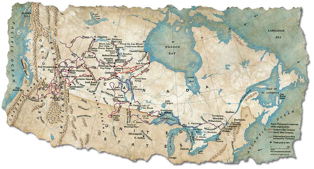
Thompson’s apprenticeship was due to end in 1791. So he appealed the company to give him surveying instruments instead of a suit of clothes. He traveled to York Factory where he presumably took possession of his new instruments. With these new instruments he set out to find a new shorter route to the fur-rich Athabasca country by way of the Churchill River and it wasn’t until 1996 and several trips that Thompson could find a more direct route to that country. In the winter of 1796-97, unhappy with Hudson Bay Company’s strong emphasis on trade, Thompson left the organization to cross over to a rival company called the North West Company. It was here that Thompson was asked by his new employers on his first major survey to explore the territory west of Lake Superior and the 49th parallel, which eventually became the US and Canada boundary. It’d be interesting to note that his journals contained hundreds of pages, of not just mapped land but also the cultural and religious practices of the inhabitants. His maps provided complete records of more than 3.9 million square kilometre and dozens of First Nation bands. Thompson thus also contributed to the knowledge of the overall geography of the northern part of the American continent.
Later Years and Death
He spent the next 15 years at North West Company exploring various parts of North America the details of which are beyond the purview of this article. But in all he spent 27 years mapping the west and over his entire career he had travelled and surveyed 100,000 km by foot, canoe and horseback! Thompson was aware that much of the lands that he had helped put on the map would eventually become farmlands pushing the aboriginal people out of it. He moved to Montreal in 1812 so that his children could get formal education doing odd jobs to pay the rent and kept working on the maps he had drawn of the west. The Canadian Encyclopedia mentions that he couldn’t find a publisher for his maps eventually selling it to Arrowsmith, a London-based publisher for 150 pounds. Arrowsmith didn’t publish it in Thompson’s name to earn him credit for his work, instead used the maps to correct their own. Thompson died in poverty and obscurity in 1857 and three months later his wife Charlotte passed away. Their marriage had lasted almost 60 months. Both are buried side by side in Montréal’s Mount Royal Cemetery.
Conclusion and Legacy
David Thompson’s survey and maps delineated the boundaries we live with today. He’s also credited with envisioning Canada as a modern nation which included vast western territories. David Thompson’s effort to not just mapping the lands but also the aboriginal cultural and religious practices is commendable and invaluable. Of course I can also value his work more closely because I have an impassioned love for hiking and geography. Though I still can’t find a ready reference of a timeline of Thompson’s surveys, I’d continue my efforts towards making that list. The Canadian government issued a commemorative stamp in 1957 on the centenary of his passing away.
References:
- Thompson Travels [Featured Image] http://www.archives.gov.on.ca/en/explore/online/thompson/geographer.aspx
- David Thompson (Explorer) https://en.m.wikipedia.org/wiki/David_Thompson_(explorer)
- The Life of David Thompson: http://www.northwestjournal.ca/V1.htm
- David Thompson – North America’s Greatest Geographer: http://www.archives.gov.on.ca/en/explore/online/thompson/geographer.aspx