canada

Co-Creation in Hiring for UX

The Role of Co-Creation in Hiring for UX

A case for using a ‘co-creation’ process for hiring UX Designers.

I prefer working in a Co-Creation design process for products, which looks like this.

DEFINE (The Problem) ⟶ ORGANIZE (The Information) ⟶ CONCEIVE & ANALYZE (The Ideas) ⟶ BUILD (The Prototypes) ⟶ DISCUSS/ITERATE (On The Feedback)  ⟶ IMPROVE (The Design). Loopback until I get to a design solution which works for the user in a co-creation process.

The purpose of a ‘Co-Creation’ session is to assemble a group of people you’re designing for and include them in the design process.

This ensures that, of all the other things, I get a chance to capture divergent insights in drawing an empathetic view of how a product could be perceived and used. So why not use the co-creation process in hiring for UX?

Continue reading…

A Report from TECHSPO Toronto 2017

I was at the TECHSPO 2017 Toronto yesterday at the Toronto Marriott Downtown Eaton Centre Hotel, having registered back in December 2016 this was an event highly recommended by an acquaintance to find out the local technology landscape.

I was anticipating a high-energy congregation of tech enthusiasts with several booths as is expected of large trade shows and expos, however, I was left disappointed at the thin crowd and fewer tech companies being represented at today’s event, while I guess my timing went awry because most of the exhibitors were at lunch break! Moreover, I’m glad I attended because there was a lot to discover about digital marketing and VR/AR from the companies (out of 13 that were represented) I was able to interact.

Continue reading…

West Duffin Creek

Seaton Trail

It was a cold November morning when we reached the Concession 3 parking lot of the Seaton Trail to begin our 26km hike today. The Seaton Trail, with a distance of 12.9 km from 3rd Concession near Brock Road northwest to Highway 7 at Green River is owned by The City of Pickering and managed by the Whitevale Community and Grand Valley Park.

I noticed a remarkable sight about the place when I looked around – it was swamped with dogs! And I realized that’s because of an Offleash Dog Park within the Seaton Trail area. And before I knew what was going on I was dashing against my furry buddies on the trail as they were scurrying around enjoying the freedom and fresh air. I also suspect they were keeping themselves warm by zipping in the wintery morning.

The trail is marked with blazes as well as numbers all along the official route, so getting lost was almost next to impossible, but still one needed to keep a watch. The numbers I was referring to corresponded to the trail we were taking. For instance ‘3N013′ would mean:
– 3 (Whitevale to Green River section)
– N (Northbound direction; S would be Southbound)
– 013 (sequential number of the trailhead)

There were also blazes – a Single blaze meant the trail proceeds straight and Double Blaze would signify oncoming turns; left or right, depending upon the placement.

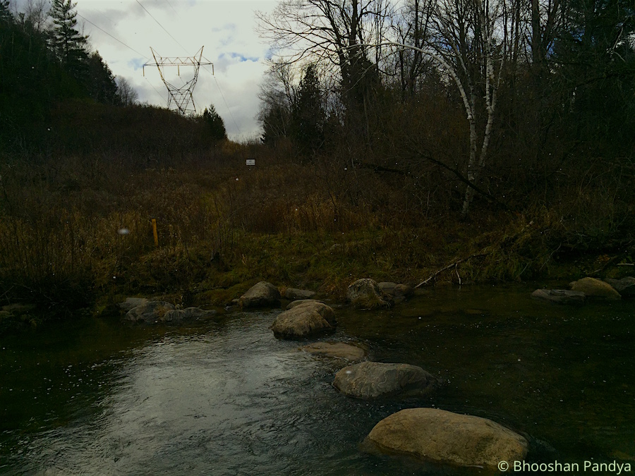
The cold weather and the winds were unrelenting. Within the first 15 mins of the trail I met a steep, never-ending hillock where I had to start dealing with a running nose and which would be an endless exercise throughout the hike. As well as certain muddy patches due to the overnight showers (we were informed about this situation) that provided some challenge for me. The plunge I had taken during the hike last week was still afresh and though I did slip a few times in the mud it wasn’t much serious but did race my heart a bit. At one point, we had planned to cross the West Duffins Creek stepping on large boulders to make the trail interesting, but unfortunately the waters had risen quite alarmingly almost submerging the rocks. Some adventurous hikers in the team brought along a tree log from the bushes in trying to form a bridge. But that plan was dumped as quickly as it materialized because the log was very unstable and it would have caused a human disaster of an unimaginable size.

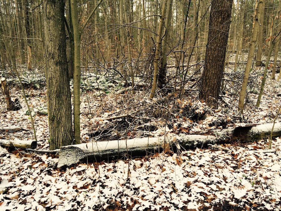
The terrain along the densely wooded area disguised itself with leaves and tree roots that reminded me once again of the Durham Regional Forest (but no biking trails this time). Also a reminder that I should be cautious in deciding my next steps (literally). We were supposed to keep up a speed of 5.5-6kmph all along the way but found that some members had started to feel the exhaustion quite early and we had to stop at regular spots to let others catch up. This became more prevalent when we headed back towards the starting point post-lunch. After a long arduous walk in the flurries and wet terrain, we settled in a dingy shed at the Whitevale Park for our meals. The flurries had given way to a nice snow shower which came down heavily. The green park was bathed in white, and so ravishingly. My hands were freezing outright as I tried to munch ferociously on the Falafel burrito and finish it faster so I can get my hands tucked inside my jacket as quickly.

As we continued beyond the park we took deviated from the main trail to explore the Whitevale Dam, where I quite ignorantly assumed we had reached the end of the trail to turn back. A really simple and a short dam built to offer a physical barrier to separate migratory fish species such as rainbow trout and chinook salmon (downstream of the dam) from native brook trout (upstream of the dam). At which point the Sun came out briefly as we scanned the beautiful marshy landscape near the dam, as the flurries returned. Continuing onwards to Green Park parking lot the path became more smoother and muddier once we passed under the 407. It was around 1-1:15 PM when we reached the destination to turn back. We had maintained a steady pace of 5.5-6kmph which still did not satisfy certain members of the group. They wanted the pace quicker! Nevertheless given the muddy and hilly terrain I thought I had done well, though admittedly my confidence levels were at an all time low criss-crossing the swampy patches.

We turned around to go back. At this pace it was likely that we would reach the starting point at the Concession 3 parking lot by 4:45PM. After we passed the Whitevale Park (where we had our lunch before) I took the lead with another member until the Clarkes Hollow Parking. We went with such ferocious pace meeting the trail bends and the hillock, almost jogging through the woods, that the distance between us and the rest of the group widened. We had no choice but to wait for them and take a breather. The downhills before had now become uphill leading to even steeper climbs post the lunch period. The exhaustion had begun to set in for some members, and quite rightly so, while I was working hard to keep the momentum from dropping. The exhaustion wasn’t personally felt until I reached the end at 4:15-20PM but it wasn’t as much as a little soreness. We had picked such amazing pace that despite the halts we took we still managed to save 30 minutes from the overall hike time. It was yet another awesome hike that ended, that goes straight into my book of memoirs.

Durham Regional Forest

Durham Regional Forest, Walker Woods and Glen Major

On a cloudy and cold November-14, I set out to hike a distance of about 25 km at the Durham Regional Forest , Walker Woods and Glen Major areas. I undermined the weather at a cost because in the adjoining forest area it had snowed the previous night, with a high temperature of only around 2ºC. I went easy on the warm clothes because the hike makes you sweaty after all. Also this was a fast hike where a consistent speed of about 5.5 km/h had to be maintained all throughout.

This hike was expected on a hilly terrain but not biking trails which meander endlessly up and down slopes. It makes a long hike challenging with the prevailing weather system. The fallen leaves hide tree roots invisible to naked eyes, and at a faster pace on the slippery leaves, one can could trip and fall. As I tumbled today while attempting a fast descent on a slippery, rocky slope that wasn’t even part of the biking trail. I landed on my back and my right thumb got smashed badly in the sudden fall. I was so stunned by the plunge over the slope that I wasn’t even aware what had happened until about a few minutes later. I think I should be doing okay in a few days.

At 12:30 PM, around the halfway distance mark we all settled on the dry grass near an old barn for a 10-minute short lunch break. We were looking to shelter ourselves from the cold winds but brief stops such as these make you colder in no time, while the Sun showed up only momentarily to brighten things up. Surprisingly while we were all focussed on our munching, a golden retriever came out of nowhere from the field, dashed towards us and started sniffing around the group. He obviously got a whiff of the meals and decided to have a share of it. We were only too glad to do the honours and he disappeared in the shrubs wagging his tail merrily. But reappeared minutes later with three of his doggie friends! He may have shared the news of some Good Samaritans beside the old barn offering free food. Unfortunately we had finished our lunch and were ready to hit the trail by then. It isn’t uncommon for owners to let their friendly dogs off-leash in these parts of wilderness. We continued meandering through the Walker Woods and Glen Major forest and the endless biking trails again. The serpentine trails would often break into forks at several places and Arnie, our group leader would look at the skies to decide on the direction to take. Thankfully at every few kilometres of the nature trail the park authorities have set up wooden masts with a unique number and a small map of the trail around which corresponds to our location and onwards – the map shows the unique pole numbers and the direction so the travellers could decide where they would like to go. The ever so indulgent group would collectively surround the measly shaft for a lengthy discussion on the next steps. The Sun outnumbered by the clouds wasn’t helping us much but the maps on the numbered posts provided stronger clues on the trail towards the parking lot where our hike was culminating. We were told to look for a pair of communication towers on the northern end of the trail from where the parking lot would be about 2.5 kms. When we saw the towers it raised my hopes and infused a new vigour to continue marching on with an even greater force towards the goal. Between washroom breaks and the odd humour, the group managed to keep up the pace and stayed together until the end of the hike. The sun never showed up afterwards and the cold wasn’t something to write home about.

Personally, my thumb episode took the focus and fun away from the hike. I couldn’t indulge completely on the trail then or the landscape which was the saddest part of the journey. The elevation wasn’t much although there were some hills but mostly biking trails. And the faster pace on the slippery leaves along the ever-changing terrain ensured limitless challenge for me. Despite everything this hike would stay a memorable one for me for different reasons.

Featured Photo Courtesy: © 2015 Bhooshan Pandya. Should Not Be Reproduced Without Permission.

Thompson's Travels

The Great Explorer

Had I not been watchful about the TV commercials, I would have completely overlooked discovering this great explorer of Canada (or should I say North America). It came as a total surprise to me that over his longish career Thompson mapped over 3.9 million square kilometres of North America and he was described as “the greatest land geographer who ever lived”.

The Beginnings
David Thompson was born to Welsh migrants on 30 April 1770 in Westminster, England. Through personal hardships including losing his father at age two he eventually graduated to the Grey Coat mathematical school where he was introduced to basic navigation skills. His studies included algebra, trigonometry, geography, and navigation using ‘practical astronomy’. This would form the basis of his interest in exploration and his future career. In May 1784, at the ripe age of 14, he entered into a seven-year apprenticeship in fur-trading business with the Hudson’s Bay Company and arrived in Churchill (now in Manitoba). He never saw his mother or England again. At Churchill he was put to work copying personal papers of the governor of Fort Churchill, Samuel Hearne, and then transferred to nearby York Factory, a fur-trading post. And over the next few years spent time as a clerk at Cumberland House, Saskatchewan and South Branch House before arriving at Manchester House in 1787.

Training and First Measurement
It was at Manchester House that Thompson had a serious fall breaking his leg and spent the next two winters convalescing. During which time he refined and expanded his mathematical, astronomical and surveying skills under the supervision of Hudson’s Bay Company surveyor Philip Turnor. It took Thompson a full year to recover but was left with a limp for the rest of his life. It was here on February 1, 1790 that Thompson recorded his first navigational measurement to gain the longitude of Cumberland House. Over the next 4 months he would also calculate the latitude for the same location at 53° 56′ 44″ N by 102° 13′ W. During this navigational training in that winter, Thompson was left blind in his right eye probably due to observing the sun without proper eye protection.

End of Apprenticeship and Surveys
Thompson’s apprenticeship was due to end in 1791. So he appealed the company to give him surveying instruments instead of a suit of clothes. He traveled to York Factory where he presumably took possession of his new instruments. With these new instruments he set out to find a new shorter route to the fur-rich Athabasca country by way of the Churchill River and it wasn’t until 1996 and several trips that Thompson could find a more direct route to that country. In the winter of 1796-97, unhappy with Hudson Bay Company’s strong emphasis on trade, Thompson left the organization to cross over to a rival company called the North West Company. It was here that Thompson was asked by his new employers on his first major survey to explore the territory west of Lake Superior and the 49th parallel, which eventually became the US and Canada boundary. It’d be interesting to note that his journals contained hundreds of pages, of not just mapped land but also the cultural and religious practices of the inhabitants. His maps provided complete records of more than 3.9 million square kilometre and dozens of First Nation bands. Thompson thus also contributed to the knowledge of the overall geography of the northern part of the American continent.

Later Years and Death
He spent the next 15 years at North West Company exploring various parts of North America the details of which are beyond the purview of this article. But in all he spent 27 years mapping the west and over his entire career he had travelled and surveyed 100,000 km by foot, canoe and horseback! Thompson was aware that much of the lands that he had helped put on the map would eventually become farmlands pushing the aboriginal people out of it. He moved to Montreal in 1812 so that his children could get formal education doing odd jobs to pay the rent and kept working on the maps he had drawn of the west. The Canadian Encyclopedia mentions that he couldn’t find a publisher for his maps eventually selling it to Arrowsmith, a London-based publisher for 150 pounds. Arrowsmith didn’t publish it in Thompson’s name to earn him credit for his work, instead used the maps to correct their own. Thompson died in poverty and obscurity in 1857 and three months later his wife Charlotte passed away. Their marriage had lasted almost 60 months. Both are buried side by side in Montréal’s Mount Royal Cemetery.

Conclusion and Legacy
David Thompson’s survey and maps delineated the boundaries we live with today. He’s also credited with envisioning Canada as a modern nation which included vast western territories. David Thompson’s effort to not just mapping the lands but also the aboriginal cultural and religious practices is commendable and invaluable. Of course I can also value his work more closely because I have an impassioned love for hiking and geography. Though I still can’t find a ready reference of a timeline of Thompson’s surveys, I’d continue my efforts towards making that list. The Canadian government issued a commemorative stamp in 1957 on the centenary of his passing away.

References: